| Location |
| City: | | Rhinelander, Wisconsin, United States |
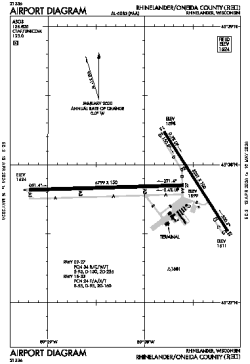
| Name: | Rhinelander/Oneida County Airport |
| ICAO / IATA: | KRHI / RHI |
| FAA: | RHI |
Details |
| Type: | Airport (Part 139 Class I) |
| Use: | Public/Civil |
| Latitude: | 45°37'51"N (45.630901) |
| Longitude: | 89°28'00"W (-89.466627) |
| Datum: | WGS 1984 |
| Elevation: | 1623 ft (495 m) |
| Runways: | 2 |
| Longest: | 6800 × 150 ft (2073 × 45.5 m) |
Time |
| Timezone: | UTC+28:08 (DST+31:08) |
| Local Time: | |
Weather |
| METAR: | KRHI | 041408Z AUTO 10009KT 3SM FZRA BR OVC007 01/M01 A2955 RMK AO2 RAE08FZRAB08 P0004 I1001 T00111011
|
| TAF: | KRHI | 041139Z 0412/0512 09010KT 3SM -FZRA BR OVC006 TEMPO 0412/0416 1SM FZRA BR OVC003
FM041700 36006KT 4SM -FZRA BR OVC004
FM041900 33008KT 5SM -FZDZ BR OVC006
FM042300 33010G15KT P6SM BKN008
FM050100 33008KT P6SM BKN014
FM050800 36004KT P6SM SCT020
|
Related Locations |
| Nearby: | |
| Farthest: | YAUG: 10926 mi / 17584 km
Augusta [Augusta Airport], WA, AU |
Find: |
|
Other Information |
Maps:
|
Links:
|
Sources:
|
|