| Location |
| City: | | Rogers, Arkansas, United States |
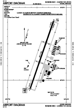
| Name: | Rogers Exec - Carter Field |
| ICAO / IATA: | KROG / ROG |
| FAA: | ROG |
Details |
| Type: | Airport (Airfield) |
| Use: | Public/Civil |
| Latitude: | 36°22'21"N (36.372417) |
| Longitude: | 94°06'25"W (-94.106971) |
| Datum: | WGS 1984 |
| Elevation: | 1358 ft (414 m) |
| Runways: | 1 |
| Longest: | 6011 × 100 ft (1832 × 30.5 m) |
Time |
| Timezone: | UTC+28:08 (DST+31:08) |
| Local Time: | |
Weather |
| METAR: | KROG | 041414Z 22010KT 10SM BKN018 16/14 A2975 RMK AO2
|
| TAF: | KROG | 041128Z 0412/0512 19018G24KT P6SM SCT025 TEMPO 0412/0414 BKN025
FM041500 22012G19KT P6SM SCT035
FM041900 31010KT P6SM SCT040
FM050000 36007KT P6SM SCT040 SCT250
FM050800 VRB04KT P6SM BKN015
|
Related Locations |
| Nearby: | |
| Farthest: | YAUG: 10791 mi / 17366 km
Augusta [Augusta Airport], WA, AU |
Find: |
|
Other Information |
Maps:
|
Links:
|
Sources:
|
|