| Location |
| City: | | San Francisco, California, United States |
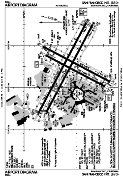
| Name: | San Francisco International Airport |
| ICAO / IATA: | KSFO / SFO |
| FAA: | SFO |
Details |
| Type: | Airport (Part 139 Class I) |
| Use: | Public/Civil |
| Latitude: | 37°37'08"N (37.618806) |
| Longitude: | 122°22'31"W (-122.375416) |
| Datum: | WGS 1984 |
| Elevation: | 13 ft (4 m) |
| Runways: | 4 |
| Longest: | 11870 × 200 ft (3618 × 61 m) |
Time |
| Timezone: | UTC+26:08 (DST+29:08) |
| Local Time: | |
Weather |
| METAR: | KSFO | 041407Z 25013KT 9SM -RA FEW008 BKN018 BKN034 09/06 A2955 RMK AO2 P0000 T00940061
|
| TAF: | KSFO | 041138Z 0412/0518 21015G23KT P6SM -SHRA FEW015 BKN022 OVC035
FM041600 24020G28KT P6SM -SHRA SCT020 BKN035
FM050300 26015G22KT P6SM -SHRA OVC025
FM050800 25018KT P6SM -SHRA OVC025
FM051500 27010KT P6SM VCSH SCT050 BKN150
|
Related Locations |
| Nearby: | |
| Farthest: | FTU: 11365 mi / 18290 km
Tolagnaro [Maurillac Airport (Fort Dauphin Airport)], MG |
Find: |
|
Other Information |
Maps:
|
Delays:
|
Links:
|
Sources:
|
|