| Location |
| City: | | Springfield, Missouri, United States |
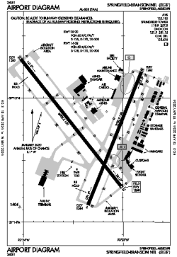
| Name: | Springfield-Branson National Airport |
| ICAO / IATA: | KSGF / SGF |
| FAA: | SGF |
Details |
| Type: | Airport (Part 139 Class I) |
| Use: | Public/Civil |
| Latitude: | 37°14'44"N (37.245661) |
| Longitude: | 93°23'19"W (-93.388626) |
| Datum: | WGS 1984 |
| Elevation: | 1268 ft (386 m) |
| Runways: | 2 |
| Longest: | 8000 × 150 ft (2438 × 45.5 m) |
Time |
| Timezone: | UTC+28:08 (DST+31:08) |
| Local Time: | |
Weather |
| METAR: | KSGF | 041352Z 16006KT 7SM OVC028 15/12 A2971 RMK AO2 SLP056 T01500122
|
| TAF: | KSGF | 041120Z 0412/0512 17013KT P6SM BKN025 WS020/22040KT
FM041400 18012G17KT P6SM BKN025
FM041700 24012KT P6SM BKN030
FM041900 34012KT P6SM OVC015
FM050300 03009KT P6SM OVC010
|
Related Locations |
| Nearby: | |
| Farthest: | YAUG: 10833 mi / 17434 km
Augusta [Augusta Airport], WA, AU |
Find: |
|
Other Information |
Maps:
|
Delays:
|
Links:
|
Sources:
|
|