| Location |
| City: | | Santa Ana, California, United States |
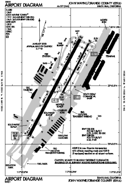
| Name: | John Wayne/Orange County Airport |
| ICAO / IATA: | KSNA / SNA |
| FAA: | SNA |
Details |
| Type: | Airport (Part 139 Class I) |
| Use: | Public/Civil |
| Latitude: | 33°40'32"N (33.675662) |
| Longitude: | 117°52'06"W (-117.868232) |
| Datum: | WGS 1984 |
| Elevation: | 55 ft (17 m) |
| Runways: | 2 |
| Longest: | 5700 × 150 ft (1737 × 45.5 m) |
Time |
| Timezone: | UTC+26:08 (DST+29:08) |
| Local Time: | |
Weather |
| METAR: | KSNA | 041353Z 15005KT 10SM FEW030 OVC039 12/09 A2986 RMK AO2 RAB10E49 SLP110 P0013 T01170094
|
| TAF: | KSNA | 041329Z 0413/0512 VRB05KT P6SM -SHRA SCT020 BKN040 TEMPO 0413/0416 2SM RA BKN018
FM041600 16010G18KT P6SM VCSH SCT025 OVC035
FM041800 19014G22KT P6SM -SHRA SCT020 OVC030
FM042000 21012G20KT 4SM -RA SCT015 OVC025
FM050300 23008KT P6SM -SHRA SCT025 BKN035
|
Related Locations |
| Nearby: | |
| Farthest: | ZSE: 11488 mi / 18489 km
St-Pierre (St-Pierre de la Réunion) [Pierrefonds], RE |
Find: |
|
Other Information |
Maps:
|
Delays:
|
Links:
|
Sources:
|
|