| Location |
| City: | | Salinas, California, United States |
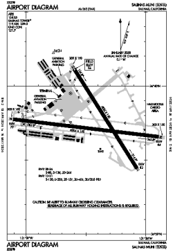
| Name: | Salinas Municipal Airport |
| ICAO / IATA: | KSNS / SNS |
| FAA: | SNS |
Details |
| Type: | Airport (Airfield) |
| Use: | Public/Civil |
| Latitude: | 36°39'45"N (36.662411) |
| Longitude: | 121°36'26"W (-121.607153) |
| Datum: | WGS 1984 |
| Elevation: | 84 ft (26 m) |
| Runways: | 2 |
| Longest: | 6004 × 150 ft (1830 × 45.5 m) |
Time |
| Timezone: | UTC+26:08 (DST+29:08) |
| Local Time: | |
Weather |
| METAR: | KSNS | 041353Z AUTO 25009KT 10SM SCT018 BKN039 OVC060 11/08 A2963 RMK AO2 RAB27E50 SLP043 P0000 T01060078
|
| TAF: | KSNS | 041138Z 0412/0512 22005KT 6SM -RA FEW025 BKN040 OVC050
FM041900 24012KT P6SM -SHRA FEW025 BKN040 OVC050
FM050000 25015G23KT P6SM VCSH OVC050
FM050300 23012G18KT P6SM -RA OVC040
|
Related Locations |
| Nearby: | |
| Farthest: | FTU: 11387 mi / 18326 km
Tolagnaro [Maurillac Airport (Fort Dauphin Airport)], MG |
Find: |
|
Other Information |
Maps:
|
Links:
|
Sources:
|
|