| Location |
| City: | | Fairfield, California, United States |
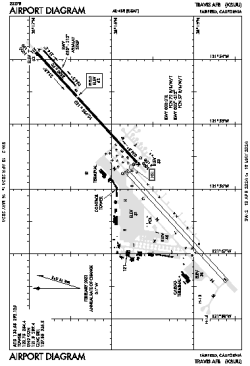
| Name: | Travis AFB |
| ICAO / IATA: | KSUU / SUU |
| FAA: | SUU |
Details |
| Type: | Airport (Airfield) |
| Use: | Military |
| Latitude: | 38°15'52"N (38.264537) |
| Longitude: | 121°55'27"W (-121.924130) |
| Datum: | WGS 1984 |
| Elevation: | 63 ft (19 m) |
| Runways: | 3 |
| Longest: | 11001 × 300 ft (3353 × 91.5 m) |
Time |
| Timezone: | UTC+26:08 (DST+29:08) |
| Local Time: | |
Weather |
| METAR: | KSUU | 041408Z AUTO 20012KT 10SM FEW005 BKN012 OVC019 09/08 A2949 RMK AO2 SLP993
|
| TAF: | KSUU | 040300Z 0403/0509 21009KT 9000 -SHRA BKN015 OVC030 QNH2969INS BECMG 0408/0409 12009KT 9000 -SHRA OVC006 QNH2962INS BECMG 0414/0415 20009KT 9000 -SHRA OVC015 QNH2956INS BECMG 0417/0418 23012G18KT 9000 -SHRA BKN014 QNH2959INS TEMPO 0418/0502 23018G25KT 520009 BECMG 0502/0503 23006KT 9999 NSW SKC QNH2965INS BECMG 0508/0509 VRB06KT 9999 SCT014 QNH2968INS TX10/0403Z TN07/0411Z
|
Related Locations |
| Nearby: | |
| Farthest: | FTU: 11314 mi / 18209 km
Tolagnaro [Maurillac Airport (Fort Dauphin Airport)], MG |
Find: |
|
Other Information |
Maps:
|
Links:
|
Sources:
|
|