| Location |
| City: | | Aurora, Oregon, United States |
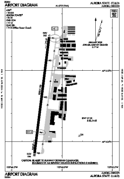
| Name: | Aurora State Airport |
| ICAO: | KUAO |
| FAA: | UAO |
Details |
| Type: | Airport (Airfield) |
| Use: | Public/Civil |
| Latitude: | 45°14'50"N (45.247126) |
| Longitude: | 122°46'12"W (-122.770046) |
| Datum: | WGS 1984 |
| Elevation: | 199 ft (61 m) |
| Runways: | 1 |
| Longest: | 5003 × 100 ft (1525 × 30.5 m) |
Time |
| Timezone: | UTC+26:08 (DST+29:08) |
| Local Time: | |
Weather |
| METAR: | KUAO | 041353Z AUTO 00000KT 10SM BKN006 BKN012 OVC070 02/01 A2945 RMK AO2 UPB1256E08 CIG 004V008 SLP973 P0000 T00170011
|
| TAF: | KUAO | 041139Z 0412/0512 15006KT P6SM -SHRASN FEW007 BKN015 OVC030 TEMPO 0412/0416 1SM -SHSN BKN007 OVC020
FM041600 13005KT P6SM -SHSN SCT015 BKN025 OVC035 TEMPO 0416/0420 3SM -SHSN BKN015 OVC025
FM050300 06007KT P6SM VCSH BKN025 BKN045
|
Related Locations |
| Nearby: | |
| Farthest: | FAME: 11504 mi / 18514 km
Marion Island, Prince Edward Islands, WC, ZA |
Find: |
|
Other Information |
Maps:
|
Links:
|
Sources:
|
|