| Location |
| City: | | Youngstown/Warren, Ohio, United States |
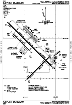
| Name: | Youngstown/Warren Regional |
| ICAO / IATA: | KYNG / YNG |
| FAA: | YNG |
Details |
| Type: | Airport (Part 139 Class IV) |
| Use: | Public/Civil |
| Latitude: | 41°15'42"N (41.261583) |
| Longitude: | 80°40'49"W (-80.680360) |
| Datum: | WGS 1984 |
| Elevation: | 1191 ft (363 m) |
| Runways: | 3 |
| Longest: | 9003 × 150 ft (2744 × 45.5 m) |
Time |
| Timezone: | UTC+29:08 (DST+32:08) |
| Local Time: | |
Weather |
| METAR: | KYNG | 041351Z 17006KT 10SM FEW045 SCT250 08/03 A2998 RMK AO2 SLP159 T00830028
|
| TAF: | KYNG | 041124Z 0412/0512 18007KT P6SM FEW080 SCT250
FM042300 18010G20KT 6SM -SHRA OVC045
FM050100 19010G20KT 4SM -SHRA BR OVC020
FM050300 21010G20KT 2SM -SHRA BR OVC008
FM050500 23008KT P6SM OVC008
FM050900 26009KT P6SM OVC010
|
Related Locations |
| Nearby: | |
| Farthest: | YAUG: 11452 mi / 18430 km
Augusta [Augusta Airport], WA, AU |
Find: |
|
Other Information |
Maps:
|
Delays:
|
Links:
|
Sources:
|
|