| Location |
| City: | | Lansing, Michigan, United States |
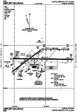
| Name: | Capital Region International Airport |
| ICAO / IATA: | KLAN / LAN |
| FAA: | LAN |
Details |
| Type: | Airport (Part 139 Class I) |
| Use: | Public/Civil |
| Latitude: | 42°46'43"N (42.778639) |
| Longitude: | 84°35'10"W (-84.586193) |
| Datum: | WGS 1984 |
| Elevation: | 860 ft (262 m) |
| Runways: | 3 |
| Longest: | 8506 × 150 ft (2593 × 45.5 m) |
Time |
| Timezone: | UTC+29:08 (DST+32:08) |
| Local Time: | |
Weather |
| METAR: | KLAN | 041353Z 18012KT 10SM CLR 09/07 A2978 RMK AO2 SLP089 T00940067
|
| TAF: | KLAN | 041136Z 0412/0512 18008KT P6SM BKN035 WS020/24035KT
FM041500 19012KT 5SM -SHRA BR OVC025 WS020/21040KT
FM041800 19014G23KT 3SM -SHRA OVC015
FM042100 21013G22KT 1 1/2SM -RA BR OVC008
FM050100 23012KT 4SM -DZ BR OVC009
FM050400 25011KT 6SM BR OVC015
FM050800 30013KT P6SM BKN015
|
Related Locations |
| Nearby: | |
| Farthest: | YAUG: 11226 mi / 18066 km
Augusta [Augusta Airport], WA, AU |
Find: |
|
Other Information |
Maps:
|
Delays:
|
Links:
|
Sources:
|
|