| Location |
| City: | | Leeds/Bradford, Yorkshire, England, United Kingdom |
| Near (Alt.): | Yeadon |
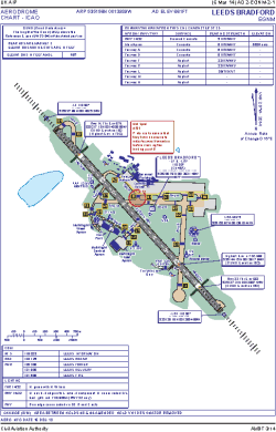
| Name: | Leeds Bradford International Airport |
| ICAO / IATA: | EGNM / LBA |
Details |
| Type: | Airport (Aerodrome, Airfield) |
| Use: | Public/Civil |
| Latitude: | 53°51'58"N (53.866025) |
| Longitude: | 1°39'39"W (-1.660768) |
| Elevation: | 681 ft (208 m) |
| Runways: | 1 |
| Longest: | 7382 × 151 ft (2250 × 46 m) |
Time |
| Timezone: | UTC+0 (DST+3) |
| Local Time: | |
Weather |
| METAR: | EGNM | 041350Z 28014KT 9999 FEW026 07/02 Q1013
|
| TAF: | EGNM | 041103Z 0412/0512 27018KT 9999 SCT020 BECMG 0419/0422 24008KT TEMPO 0500/0507 6000 PROB30 0502/0507 2000 BR BECMG 0507/0510 14010KT 2000 BR BKN002 PROB40 0507/0512 0300 FG FZFG VV///
|
Related Locations |
| Nearby: | |
| Farthest: | NZBA: 11783 mi / 18963 km
Balclutha, OTA, NZ |
Find: |
|
Other Information |
Maps:
|
Links:
|
Sources:
|
|