| Location |
| City: | | Latrobe, Pennsylvania, United States |
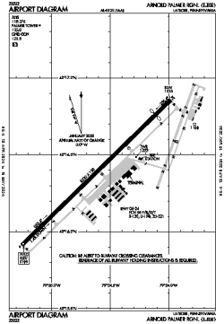
| Name: | Arnold Palmer Regional |
| ICAO / IATA: | KLBE / LBE |
| FAA: | LBE |
Details |
| Type: | Airport (Part 139 Class I) |
| Use: | Public/Civil |
| Latitude: | 40°16'23"N (40.273100) |
| Longitude: | 79°24'37"W (-79.410325) |
| Datum: | WGS 1984 |
| Elevation: | 1198 ft (365 m) |
| Runways: | 1 |
| Longest: | 8222 × 150 ft (2506 × 45.5 m) |
Time |
| Timezone: | UTC+29:08 (DST+32:08) |
| Local Time: | |
Weather |
| METAR: | KLBE | 041353Z 00000KT 10SM SKC 02/02 A3005
|
| TAF: | KLBE | 041134Z 0412/0512 18005KT P6SM SCT250
FM050000 18008KT P6SM BKN050
FM050300 21008KT 6SM -RA BKN025 WS020/22040KT
FM050800 21006KT 5SM -RA OVC010 WS020/24040KT
|
Related Locations |
| Nearby: | |
| Farthest: | YAUG: 11541 mi / 18573 km
Augusta [Augusta Airport], WA, AU |
Find: |
|
Other Information |
Maps:
|
Links:
|
Sources:
|
|