| Location |
| City: | | Lake Charles, Louisiana, United States |
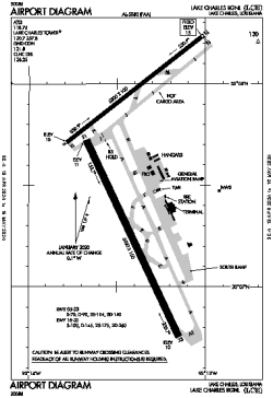
| Name: | Lake Charles Regional |
| ICAO / IATA: | KLCH / LCH |
| FAA: | LCH |
Details |
| Type: | Airport (Part 139 Class I) |
| Use: | Public/Civil |
| Latitude: | 30°07'34"N (30.126083) |
| Longitude: | 93°13'24"W (-93.223416) |
| Datum: | WGS 1984 |
| Elevation: | 14 ft (4 m) |
| Runways: | 2 |
| Longest: | 6500 × 150 ft (1981 × 45.5 m) |
Time |
| Timezone: | UTC+28:08 (DST+31:08) |
| Local Time: | |
Weather |
| METAR: | KLCH | 041353Z 19003KT 1/4SM FG VV002 19/19 A2996 RMK AO2 SLP151 T01890189 $
|
| TAF: | KLCH | 041339Z 0414/0512 16004KT 1/4SM FG VCSH VV002 TEMPO 0414/0416 2SM BR OVC005
FM041600 17006KT 4SM BR VCSH OVC007
FM041700 18007KT P6SM VCSH OVC012
FM042000 21007KT P6SM VCSH OVC020
FM050200 17003KT 4SM BR OVC005 TEMPO 0508/0512 1/2SM FG VV002
|
Related Locations |
| Nearby: | |
| Farthest: | CCK: 11041 mi / 17769 km
West Island (Pulau Panjang) [Cocos (Keeling) Islands], CC |
Find: |
|
Other Information |
Maps:
|
Delays:
|
Links:
|
Sources:
|
|