| Location |
| City: | | Montferrer, Catalonia, Spain |
| Near (Alt.): | Lleida |
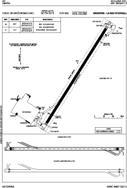
| Name: | Andorra-La Seu d'Urgell Airport (Pirineus-La Seu d'Urgell Airport) |
| ICAO / IATA: | LESU / LEU |
Details |
| Type: | Airport (Aerodrome, Airfield) |
| Use: | Public/Civil |
| Latitude: | 42°20'46"N (42.346111) |
| Longitude: | 1°24'53"E (1.414722) |
| Elevation: | 2630 ft (802 m) |
| Runways: | 1 |
| Longest: | 4157 × 92 ft (1267 × 28 m) |
Time |
| Timezone: | UTC+1 (DST+4) |
| Local Time: | |
Weather |
| METAR: | LESU | 041400Z 21005KT 170V250 CAVOK 12/M12 Q1022
|
| TAF: | LESU | 040800Z 0409/0509 VRB04KT 9999 SCT070 TX13/0414Z TNM02/0506Z
|
Related Locations |
| Nearby: | |
| Farthest: | CHT: 12288 mi / 19775 km
Waitangi [Tuuta], CIT, NZ |
Find: |
|
Other Information |
Maps:
|
Sources:
|
|