| Location |
| City: | | Lexington, Kentucky, United States |
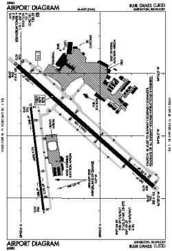
| Name: | Blue Grass Airport |
| ICAO / IATA: | KLEX / LEX |
| FAA: | LEX |
Details |
| Type: | Airport (Part 139 Class I) |
| Use: | Public/Civil |
| Latitude: | 38°02'12"N (38.036750) |
| Longitude: | 84°36'31"W (-84.608638) |
| Datum: | WGS 1984 |
| Elevation: | 979 ft (298 m) |
| Runways: | 2 |
| Longest: | 7004 × 150 ft (2135 × 45.5 m) |
Time |
| Timezone: | UTC+29:08 (DST+32:08) |
| Local Time: | |
Weather |
| METAR: | KLEX | 041354Z 17010KT 10SM CLR 11/07 A2998 RMK AO2 SLP151 T01060072
|
| TAF: | KLEX | 041135Z 0412/0512 17007KT P6SM FEW090
FM041400 18013G19KT P6SM BKN090
FM041800 19015G20KT 5SM -SHRA BR BKN015 OVC030 TEMPO 0418/0422 2SM -SHRA BR BKN008
FM050000 21011KT P6SM -SHRA OVC010
FM050700 22008KT 5SM BR OVC005
|
Related Locations |
| Nearby: | |
| Farthest: | YAUG: 11311 mi / 18203 km
Augusta [Augusta Airport], WA, AU |
Find: |
|
Other Information |
Maps:
|
Delays:
|
Links:
|
Sources:
|
|