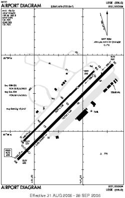
| Location |
| City: | | Liège, Liège, Belgium |
| Near (Alt.): | Luttich |
| Name: | Liège Airport (Liège-Bierset Airport) |
| ICAO / IATA: | EBLG / LGG |
Details |
| Type: | Airport (Aerodrome, Airfield) |
| Use: | Public/Civil |
| Latitude: | 50°38'11"N (50.636389) |
| Longitude: | 5°26'34"E (5.442778) |
| Elevation: | 659 ft (201 m) |
| Runways: | 2 |
| Longest: | 10784 × 148 ft (3287 × 45 m) |
Time |
| Timezone: | UTC+1 (DST+4) |
| Local Time: | |
Weather |
| METAR: | EBLG | 041350Z 19016KT CAVOK 03/M04 Q1024 TEMPO 20014G24KT
|
| TAF: | EBLG | 041100Z 0412/0518 20012KT 9999 BKN040 BECMG 0422/0424 BKN008 TEMPO 0412/0422 19015G25KT TEMPO 0501/0505 2500 RASN BKN004 TEMPO 0505/0509 BKN003
|
Related Locations |
| Nearby: | |
| Farthest: | CHT: 11950 mi / 19232 km
Waitangi [Tuuta], CIT, NZ |
Find: |
|
Other Information |
Maps:
|
Sources:
|
|