| Location |
| City: | | London, Middlesex, England, United Kingdom |
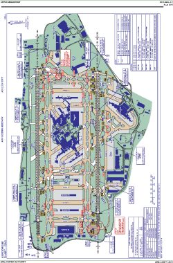
| Name: | Heathrow Airport |
| ICAO / IATA: | EGLL / LHR |
Details |
| Type: | Airport (Aerodrome, Airfield) |
| Use: | Public/Civil |
| Latitude: | 51°28'39"N (51.477500) |
| Longitude: | 0°27'41"W (-0.461388) |
| Elevation: | 83 ft (25 m) |
| Runways: | 2 |
| Longest: | 12802 × 164 ft (3902 × 50 m) |
Time |
| Timezone: | UTC+0 (DST+3) |
| Local Time: | |
Weather |
| METAR: | EGLL | 041350Z 22010KT 4000 -DZ SCT005 BKN010 OVC035 09/08 Q1016 TEMPO BKN004
|
| TAF: | EGLL | 041103Z 0412/0518 20010KT 9999 BKN012 BECMG 0412/0415 BKN006 TEMPO 0412/0420 3000 RADZ PROB40 TEMPO 0413/0420 1400 DZ BKN002 BECMG 0420/0423 6000 NSW FEW040 BECMG 0500/0503 4000 BR PROB30 TEMPO 0501/0509 0300 FG FZFG VV/// BECMG 0508/0510 7000 NSW BKN005 BECMG 0510/0513 9999 BKN020 TEMPO 0513/0518 7000 -RADZ BKN012
|
Related Locations |
| Nearby: | |
| Farthest: | NZDC: 11870 mi / 19102 km
Dunedin [City Heliport], OTA, NZ |
Find: |
|
Other Information |
Maps:
|
Links:
|
Sources:
|
|