| Location |
| City: | | Brindisi, Apulia, Italy |
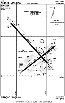
| Name: | Brindisi-Salento Airport (Brindisi Papola Casale Airport) |
| ICAO / IATA: | LIBR / BDS |
Details |
| Type: | Airport (Aerodrome, Airfield) |
| Use: | Public/Civil, Military |
| Latitude: | 40°39'27"N (40.657633) |
| Longitude: | 17°56'49"E (17.947033) |
| Datum: | WGS 1984 |
| Elevation: | 47 ft (14 m) |
| Runways: | 2 |
| Longest: | 8307 × 148 ft (2532 × 45 m) |
Time |
| Timezone: | UTC+1 (DST+4) |
| Local Time: | |
Weather |
| METAR: | LIBR | 041350Z 06013KT 9999 FEW015 BKN045 14/12 Q1013
|
| TAF: | LIBR | 041100Z 0412/0512 05018KT 8000 SCT015 BKN040 TEMPO 0412/0415 TSRA BECMG 0504/0506 35015G25KT
|
Related Locations |
| Nearby: | |
| Farthest: | CHT: 11671 mi / 18783 km
Waitangi [Tuuta], CIT, NZ |
Find: |
|
Other Information |
Maps:
|
Sources:
|
|