| Location |
| City: | | Las Vegas, Nevada, United States |
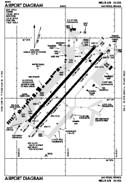
| Name: | Nellis AFB |
| ICAO / IATA: | KLSV / LSV |
| FAA: | LSV |
Details |
| Type: | Airport (Airfield) |
| Use: | Military |
| Latitude: | 36°14'10"N (36.236200) |
| Longitude: | 115°02'03"W (-115.034255) |
| Datum: | WGS 1984 |
| Elevation: | 1869 ft (570 m) |
| Runways: | 2 |
| Longest: | 10120 × 200 ft (3085 × 61 m) |
Time |
| Timezone: | UTC+26:08 (DST+29:08) |
| Local Time: | |
Weather |
| METAR: | KLSV | 041358Z 13016KT 10SM SCT070 10/05 A2975 RMK AO2A SLP068 ALSTG/SLP ESTMD T01030048 $
|
| TAF: | KLSV | 041200Z 0412/0513 15012KT 9999 SCT060 SCT210 QNH2974INS TEMPO 0412/0414 14015G25KT 520009 BECMG 0419/0420 18015G25KT 9999 SCT060 BKN090 620905 520009 QNH2971INS BECMG 0422/0423 16015G25KT 9999 VCSH BKN050 620806 520009 QNH2966INS TEMPO 0501/0506 8000 -RA BKN040 OVC070 BECMG 0508/0509 18015G25KT 9999 NSW SCT050 BKN090 620905 520009 QNH2965INS TX15/0423Z TN08/0414Z
|
Related Locations |
| Nearby: | |
| Farthest: | RRG: 11291 mi / 18171 km
Plaine Corail [Sir Gaëtan Duval Airport (Plaine Corail Airport)], Rodrigues Island, MU |
Find: |
|
Other Information |
Maps:
|
Links:
|
Sources:
|
|