| Location |
| City: | | Kansas City, Missouri, United States |
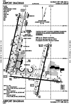
| Name: | Kansas City International Airport |
| ICAO / IATA: | KMCI / MCI |
| FAA: | MCI |
Details |
| Type: | Airport (Part 139 Class I) |
| Use: | Public/Civil |
| Latitude: | 39°17'51"N (39.297611) |
| Longitude: | 94°42'50"W (-94.713888) |
| Datum: | WGS 1984 |
| Elevation: | 1026 ft (313 m) |
| Runways: | 3 |
| Longest: | 10801 × 150 ft (3292 × 45.5 m) |
Time |
| Timezone: | UTC+28:08 (DST+31:08) |
| Local Time: | |
Weather |
| METAR: | KMCI | 041353Z 33013KT 6SM BR OVC005 M02/M03 A2980 RMK AO2 DZE01FZDZB01E51 SLP094 P0000 I1000 T10171028
|
| TAF: | KMCI | 041134Z 0412/0512 34012G26KT P6SM VCSH SCT008 BKN015 TEMPO 0412/0415 3SM SHRA OVC008
FM042100 01011KT P6SM SCT030
|
Related Locations |
| Nearby: | |
| Farthest: | YAUG: 10759 mi / 17315 km
Augusta [Augusta Airport], WA, AU |
Find: |
|
Other Information |
Maps:
|
Delays:
|
Links:
|
Sources:
|
|