| Location |
| City: | | Marietta, Georgia, United States |
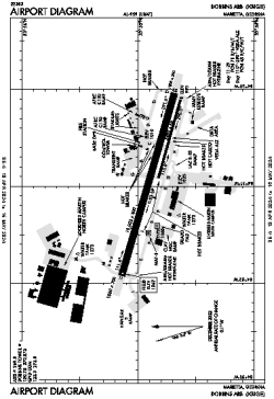
| Name: | Dobbins ARB |
| ICAO / IATA: | KMGE / MGE |
| FAA: | MGE |
Details |
| Type: | Airport (Airfield) |
| Use: | Military |
| Latitude: | 33°54'52"N (33.914442) |
| Longitude: | 84°30'51"W (-84.514246) |
| Datum: | WGS 1984 |
| Elevation: | 1068 ft (326 m) |
| Runways: | 2 |
| Longest: | 10002 × 300 ft (3049 × 91.5 m) |
Time |
| Timezone: | UTC+29:08 (DST+32:08) |
| Local Time: | |
Weather |
| METAR: | KMGE | 041356Z 10002KT 7SM FEW100 BKN250 07/06 A3009 RMK AO2A SLP193 CONTRAILS T00670055 $
|
| TAF: | KMGE | 041403Z 0414/0520 12002KT 9999 BKN100 BKN250 QNH3003INS BECMG 0500/0501 17004KT 9999 BKN020 QNH3005INS BECMG 0505/0506 19005KT 8000 BR OVC015 QNH3007INS BECMG 0508/0509 19002KT 8000 -DZ BR OVC006 QNH3004INS BECMG 0514/0515 23005KT 9999 NSW BKN015 QNH3009INS BECMG 0516/0517 24005KT 9999 BKN020 QNH3011INS TX19/0422Z TN11/0512Z
|
Related Locations |
| Nearby: | |
| Farthest: | MQZ: 11319 mi / 18216 km
Margaret River [Margaret River Airport], WA, AU |
Find: |
|
Other Information |
Maps:
|
Links:
|
Sources:
|
|