| Location |
| City: | | Sacramento, California, United States |
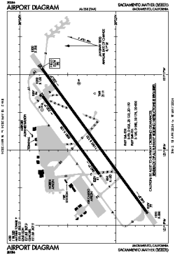
| Name: | Sacramento Mather Airport |
| ICAO / IATA: | KMHR / MHR |
| FAA: | MHR |
Details |
| Type: | Airport (Airfield) |
| Use: | Public/Civil |
| Latitude: | 38°33'19"N (38.555311) |
| Longitude: | 121°17'50"W (-121.297210) |
| Datum: | WGS 1984 |
| Elevation: | 98 ft (30 m) |
| Runways: | 2 |
| Longest: | 11301 × 150 ft (3445 × 45.5 m) |
Time |
| Timezone: | UTC+26:08 (DST+29:08) |
| Local Time: | |
Weather |
| METAR: | KMHR | 041345Z 15019G23KT 10SM BKN035 OVC042 09/08 A2949
|
| TAF: | KMHR | 041132Z 0412/0512 14015G23KT P6SM -SHRA OVC040 TEMPO 0412/0416 3SM SHRA BKN020
FM041700 20014G22KT P6SM -SHRA OVC050
FM050200 17008KT P6SM -SHRA OVC050 AMD NOT SKED
|
Related Locations |
| Nearby: | |
| Farthest: | FTU: 11277 mi / 18149 km
Tolagnaro [Maurillac Airport (Fort Dauphin Airport)], MG |
Find: |
|
Other Information |
Maps:
|
Links:
|
Sources:
|
|