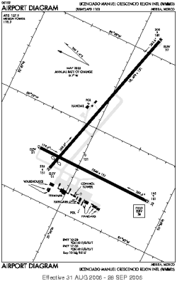
| Location |
| City: | | Mérida, Yucatán, México |
| Name: | Licenciado Manuel Crecencio Rejón International Airport |
| ICAO / IATA: | MMMD / MID |
Details |
| Type: | Airport (Aerodrome, Airfield) |
| Use: | Public/Civil, Military |
| Latitude: | 20°56'13"N (20.936981) |
| Longitude: | 89°39'28"W (-89.657671) |
| Datum: | WGS 1984 |
| Elevation: | 38 ft (12 m) |
| Runways: | 2 |
| Longest: | 10499 × 151 ft (3200 × 46 m) |
Time |
| Timezone: | UTC+28:08 (DST+30:08) |
| Local Time: | |
Weather |
| METAR: | MMMD | 041346Z 09008KT 3SM BR HZ BKN004 21/21 A2997 RMK 8/600
|
| TAF: | MMMD | 041119Z 0412/0518 10005KT P6SM SKC TX33/0420Z TN21/0412Z TEMPO 0412/0413 2SM BR BKN005
FM041600 12010KT P6SM BKN020
FM042200 12010KT P6SM SCT020
FM050300 08005KT P6SM SKC
FM051600 08010KT P6SM BKN020
|
Related Locations |
| Nearby: | |
| Farthest: | CCK: 11697 mi / 18824 km
West Island (Pulau Panjang) [Cocos (Keeling) Islands], CC |
Find: |
|
Other Information |
Maps:
|
Links:
|
Sources:
|
|