| Location |
| City: | | Eastover, South Carolina, United States |
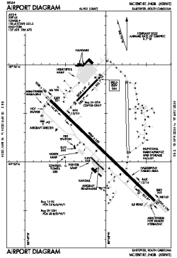
| Name: | McEntire JNGB Airport |
| ICAO / IATA: | KMMT / MMT |
| FAA: | MMT |
Details |
| Type: | Airport (Airfield) |
| Use: | Military |
| Latitude: | 33°55'15"N (33.920770) |
| Longitude: | 80°48'04"W (-80.801141) |
| Datum: | WGS 1984 |
| Elevation: | 254 ft (77 m) |
| Runways: | 3 |
| Longest: | 9010 × 150 ft (2746 × 45.5 m) |
Time |
| Timezone: | UTC+29:08 (DST+32:08) |
| Local Time: | |
Weather |
| METAR: | KMMT | 041356Z 00000KT 10SM CLR 07/07 A3009 RMK AO2A SLP193 T00740074 $
|
| TAF: | KMMT | 040800Z 0408/0514 VRB06KT 0600 FG SCT005 SCT150 QNH3002INS TEMPO 0408/0414 1200 BR BECMG 0414/0415 31006KT 9999 NSW FEW040 BKN150 QNH3000INS BECMG 0423/0424 23006KT 9999 BKN080 QNH3002INS TX19/0420Z TN01/0411Z
|
Related Locations |
| Nearby: | |
| Farthest: | MQZ: 11531 mi / 18558 km
Margaret River [Margaret River Airport], WA, AU |
Find: |
|
Other Information |
Maps:
|
Links:
|
Sources:
|
|