| Location |
| City: | | Minneapolis, Minnesota, United States |
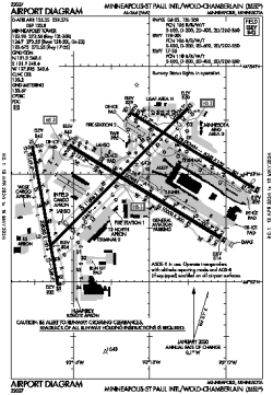
| Name: | Minneapolis-St. Paul International/Wold-Chamberlain |
| ICAO / IATA: | KMSP / MSP |
| FAA: | MSP |
Details |
| Type: | Airport (Part 139 Class I) |
| Use: | Public/Civil |
| Latitude: | 44°52'55"N (44.881972) |
| Longitude: | 93°13'18"W (-93.221777) |
| Datum: | WGS 1984 |
| Elevation: | 841 ft (256 m) |
| Runways: | 4 |
| Longest: | 11006 × 150 ft (3355 × 45.5 m) |
Time |
| Timezone: | UTC+28:08 (DST+31:08) |
| Local Time: | |
Weather |
| METAR: | KMSP | 041408Z 29014G22KT 2SM -FZDZ BR OVC006 M03/M03 A2974 RMK AO2 PRESRR P0000 I1000 T10331033
|
| TAF: | KMSP | 041139Z 0412/0518 32015G22KT P6SM OVC007
FM041800 30015G23KT P6SM OVC012
FM050200 32008KT P6SM BKN015
FM051700 05005KT 3/4SM -SN BR OVC008
|
Related Locations |
| Nearby: | |
| Farthest: | YAUG: 10771 mi / 17334 km
Augusta [Augusta Airport], WA, AU |
Find: |
|
Other Information |
Maps:
|
Delays:
|
Links:
|
Sources:
|
|