| Location |
| City: | | Mount Clemens, Michigan, United States |
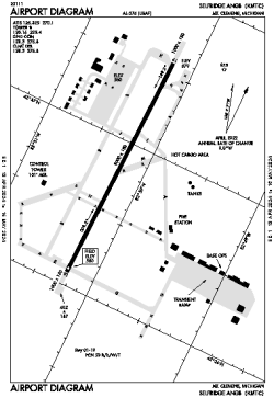
| Name: | Selfridge Angb Airport |
| ICAO / IATA: | KMTC / MTC |
| FAA: | MTC |
Details |
| Type: | Airport (Airfield) |
| Use: | Military |
| Latitude: | 42°36'50"N (42.613894) |
| Longitude: | 82°50'13"W (-82.836909) |
| Datum: | WGS 1984 |
| Elevation: | 579 ft (176 m) |
| Runways: | 1 |
| Longest: | 9000 × 150 ft (2743 × 45.5 m) |
Time |
| Timezone: | UTC+29:08 (DST+32:08) |
| Local Time: | |
Weather |
| METAR: | KMTC | 041356Z 18005KT 5SM BR BKN046 BKN055 05/05 A2985 RMK AO2A SLP116 WND DATA ESTMD T00520052
|
| TAF: | KMTC | 040900Z 0409/0515 20009KT 9999 OVC030 QNH2986INS BECMG 0411/0412 19009KT 8000 BR OVC007 QNH2978INS BECMG 0417/0418 19015KT 8000 BR OVC005 QNH2969INS BECMG 0420/0421 27012KT 8000 -SHRA BKN007 QNH2969INS BECMG 0502/0503 29015G25KT 9999 NSW OVC015 QNH2970INS BECMG 0508/0509 32012G20KT 9999 OVC020 QNH2991INS BECMG 0513/0514 34009KT 9999 BKN030 QNH3012INS TX11/0503Z TN02/0509Z LAST NO AMDS AFT 0409 NEXT 0412
|
Related Locations |
| Nearby: | |
| Farthest: | YAUG: 11312 mi / 18205 km
Augusta [Augusta Airport], WA, AU |
Find: |
|
Other Information |
Maps:
|
Links:
|
Sources:
|
|