| Location |
| City: | | Baltimore, Maryland, United States |
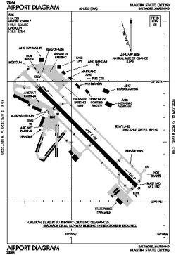
| Name: | Martin State Airport |
| ICAO / IATA: | KMTN / MTN |
| FAA: | MTN |
Details |
| Type: | Airport (Airfield) |
| Use: | Public/Civil |
| Latitude: | 39°19'32"N (39.325661) |
| Longitude: | 76°24'50"W (-76.413755) |
| Datum: | WGS 1984 |
| Elevation: | 21 ft (6 m) |
| Runways: | 1 |
| Longest: | 6997 × 180 ft (2133 × 55 m) |
Time |
| Timezone: | UTC+29:08 (DST+32:08) |
| Local Time: | |
Weather |
| METAR: | KMTN | 041345Z 29004KT 4SM BR SCT120 00/00 A3013
|
| TAF: | KMTN | 041126Z 0412/0512 00000KT 5SM BR SCT002 SCT250
FM041400 14005KT P6SM SCT090
FM050000 VRB03KT P6SM SCT090
FM050600 VRB03KT P6SM BKN050 BKN130
|
Related Locations |
| Nearby: | |
| Farthest: | YAUG: 11713 mi / 18850 km
Augusta [Augusta Airport], WA, AU |
Find: |
|
Other Information |
Maps:
|
Links:
|
Sources:
|
|