| Location |
| City: | | Montgomery, Alabama, United States |
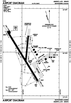
| Name: | Maxwell AFB |
| ICAO / IATA: | KMXF / MXF |
| FAA: | MXF |
Details |
| Type: | Airport (Airfield) |
| Use: | Military |
| Latitude: | 32°22'59"N (32.382944) |
| Longitude: | 86°21'57"W (-86.365777) |
| Datum: | WGS 1984 |
| Elevation: | 170 ft (52 m) |
| Runways: | 2 |
| Longest: | 8008 × 150 ft (2441 × 45.5 m) |
Time |
| Timezone: | UTC+28:08 (DST+31:08) |
| Local Time: | |
Weather |
| METAR: | KMXF | 041411Z AUTO 00000KT 2 3/4SM BR OVC004 12/12 A3007 RMK AO2 SLP185 $
|
| TAF: | KMXF | 041200Z 0412/0518 17006KT 0600 FG OVC001 QNH3000INS TEMPO 0412/0414 4800 BR FEW001 BECMG 0413/0414 05005KT 4800 BR SCT025 QNH3007INS BECMG 0414/0415 12005KT 8000 BR OVC025 QNH3003INS BECMG 0505/0506 17005KT 4800 BR OVC009 QNH3006INS BECMG 0508/0509 17005KT 0800 FG OVC003 QNH3008INS TX21/0421Z TN10/0412Z
|
Related Locations |
| Nearby: | |
| Farthest: | MQZ: 11198 mi / 18021 km
Margaret River [Margaret River Airport], WA, AU |
Find: |
|
Other Information |
Maps:
|
Links:
|
Sources:
|
|