| Location |
| City: | | McCall, Idaho, United States |
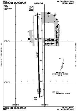
| Name: | McCall Municipal Airport |
| ICAO / IATA: | KMYL / MYL |
| FAA: | MYL |
Details |
| Type: | Airport (Airfield) |
| Use: | Public/Civil |
| Latitude: | 44°53'19"N (44.888744) |
| Longitude: | 116°06'06"W (-116.101751) |
| Datum: | WGS 1984 |
| Elevation: | 5024 ft (1531 m) |
| Runways: | 1 |
| Longest: | 6101 × 75 ft (1860 × 23 m) |
Time |
| Timezone: | UTC+27:08 (DST+30:08) |
| Local Time: | |
Weather |
| METAR: | KMYL | 041259Z AUTO 17012KT 2 1/2SM -SN BR BKN017 BKN022 OVC030 00/M02 A2936 RMK AO2 P0000 T00001017 $
|
| TAF: | KMYL | 041401Z 0414/0512 17012KT 3SM -SN BR OVC015
FM041700 16010KT P6SM VCSH OVC025
FM042300 17010KT 2SM -SN BR OVC010
|
Related Locations |
| Nearby: | |
| Farthest: | FAME: 11182 mi / 17996 km
Marion Island, Prince Edward Islands, WC, ZA |
Find: |
|
Other Information |
Maps:
|
Links:
|
Sources:
|
|