| Location |
| City: | | Nizhnekamsk, Tatarstan, Russian Federation (Russia) |
| Near (Alt.): | Naberezhnye Chelny |
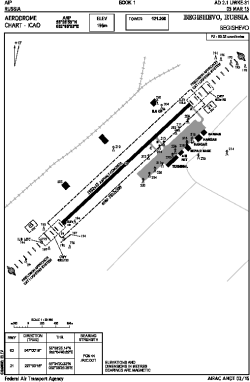
| Name: | Begishevo Airport |
| ICAO / IATA: | UWKE / NBC |
Details |
| Type: | Airport (Aerodrome, Airfield) |
| Use: | Public/Civil |
| Latitude: | 55°33'53"N (55.564722) |
| Longitude: | 52°05'33"E (52.092500) |
| Elevation: | 643 ft (196 m) |
| Runways: | 1 |
| Longest: | 8209 × 138 ft (2502 × 42 m) |
Time |
| Timezone: | UTC+3 (DST+4) |
Weather |
| METAR: | UWKE | 041400Z 05009MPS 9999 DRSN SCT100 M23/M27 Q1032 R03/421045 NOSIG RMK QFE757/1009
|
| TAF: | UWKE | 041345Z 0415/0515 05007G12MPS 9999 DRSN BKN015 TEMPO 0415/0424 07008G14MPS 3100 -SN BLSN BECMG 0500/0503 10003G09MPS TEMPO 0503/0515 14006G12MPS 3100 -SN BLSN BKN011
|
Related Locations |
| Nearby: | |
| Farthest: | NEMO: 11931 mi / 19200 km
Pacific Ocean [Oceanic Pole of Inaccessibility (Point Nemo)] |
Find: |
|
Other Information |
Maps:
|
Links:
|
Sources:
|
|