| Location |
| City: | | Nice, Provence-Alpes-Côte d'Azur, France |
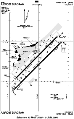
| Name: | Côte d'Azur Airport |
| ICAO / IATA: | LFMN / NCE |
Details |
| Type: | Airport (Aerodrome, Airfield) |
| Use: | Public/Civil |
| Latitude: | 43°39'55"N (43.665278) |
| Longitude: | 7°12'54"E (7.215000) |
| Elevation: | 13 ft (4 m) |
| Runways: | 2 |
| Longest: | 9711 × 148 ft (2960 × 45 m) |
Time |
| Timezone: | UTC+1 (DST+4) |
| Local Time: | |
Weather |
| METAR: | LFMN | 041400Z 21008KT 9999 FEW023 14/02 Q1022 NOSIG
|
| TAF: | LFMN | 041400Z 0415/0521 21010KT CAVOK BECMG 0418/0420 34010KT BECMG 0511/0513 22010KT BECMG 0518/0520 34010KT
|
Related Locations |
| Nearby: | |
| Farthest: | CHT: 12257 mi / 19725 km
Waitangi [Tuuta], CIT, NZ |
Find: |
|
Other Information |
Maps:
|
Links:
|
Sources:
|
|