| Location |
| City: | | Newcastle, New South Wales, Australia |
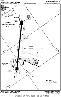
| Name: | Williamtown Airport |
| ICAO / IATA: | YWLM / NTL |
Details |
| Type: | Airport (Aerodrome, Airfield) |
| Use: | Military |
| Latitude: | 32°47'42"S (-32.794999) |
| Longitude: | 151°50'04"E (151.834444) |
| Datum: | WGS 1984 |
| Elevation: | 31 ft (9 m) |
| Runways: | 1 |
| Longest: | 7999 × 148 ft (2438 × 45 m) |
Time |
| Timezone: | UTC+10 (DST+13) |
| Local Time: | |
Weather |
| METAR: | YWLM | 041400Z AUTO 15004KT 110V200 9999 // SCT120 22/18 Q1011
|
| TAF: | YWLM | 041102Z 0412/0512 05010KT CAVOK
FM041500 14007KT 9999 SCT010
FM042200 09010KT 9999 FEW025
FM050300 08016KT CAVOK
FM050900 08008KT 9999 FEW020 PROB30 0416/0421 2000 BR BKN005
|
Related Locations |
| Nearby: | |
| Farthest: | SMA: 12099 mi / 19471 km
Santa Maria, 20, PT |
Find: |
|
Other Information |
Maps:
|
Links:
|
Sources:
|
|