| Location |
| City: | | Tokyo, Tokyo, Japan |
| Near (Alt.): | Fussa |
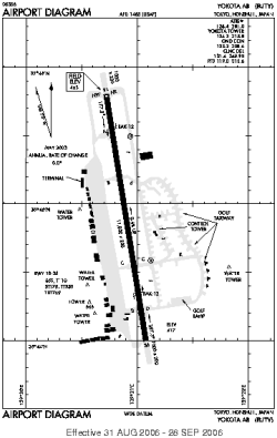
| Name: | Yokota AFB |
| ICAO / IATA: | RJTY / OKO |
Details |
| Type: | Airport (Aerodrome, Airfield) |
| Use: | Military |
| Latitude: | 35°44'55"N (35.748492) |
| Longitude: | 139°20'55"E (139.348483) |
| Datum: | WGS 1984 |
| Elevation: | 463 ft (141 m) |
| Runways: | 1 |
| Longest: | 11000 × 200 ft (3353 × 61 m) |
Time |
| Timezone: | UTC+9 (DST+11) |
| Local Time: | |
Weather |
| METAR: | RJTY | 041356Z AUTO 02011KT 10SM CLR 04/M04 A3004 RMK AO2 SLP178 T00421045 FZRANO $
|
| TAF: | RJTY | 041300Z 0413/0519 04012KT 9999 SCT030 BKN050 620503 QNH2999INS BECMG 0502/0503 15012KT 9999 SCT030 BKN040 620402 QNH3015INS TX12/0506Z TN01/0422Z LAST NO AMDS AFT 0413 NEXT 0421
|
Related Locations |
| Nearby: | |
| Farthest: | SUEX: 12291 mi / 19780 km
Montevideo East [Montevideo East UIR], UY |
Find: |
|
Other Information |
Maps:
|
Links:
|
Sources:
|
|