| Location |
| City: | | Paducah, Kentucky, United States |
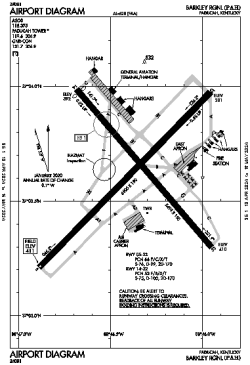
| Name: | Barkley Regional |
| ICAO / IATA: | KPAH / PAH |
| FAA: | PAH |
Details |
| Type: | Airport (Part 139 Class I) |
| Use: | Public/Civil |
| Latitude: | 37°03'37"N (37.060288) |
| Longitude: | 88°46'23"W (-88.772958) |
| Datum: | WGS 1984 |
| Elevation: | 410 ft (125 m) |
| Runways: | 2 |
| Longest: | 6500 × 150 ft (1981 × 45.5 m) |
Time |
| Timezone: | UTC+28:08 (DST+31:08) |
| Local Time: | |
Weather |
| METAR: | KPAH | 041353Z 21007KT 10SM OVC011 14/12 A2985 RMK AO2 CIG 009V013 SLP105 T01440122
|
| TAF: | KPAH | 041212Z 0412/0512 18012KT P6SM VCSH BKN015 TEMPO 0414/0418 SCT015 BKN025
FM041800 21013KT P6SM VCSH OVC008
FM050600 34008KT P6SM OVC008
|
Related Locations |
| Nearby: | |
| Farthest: | YAUG: 11088 mi / 17844 km
Augusta [Augusta Airport], WA, AU |
Find: |
|
Other Information |
Maps:
|
Delays:
|
Links:
|
Sources:
|
|