| Location |
| City: | | Yigo, Guam, United States |
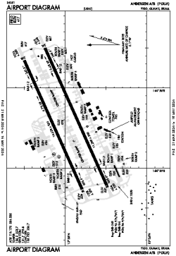
| Name: | Andersen AFB |
| ICAO / IATA: | PGUA / UAM |
| FAA: | UAM |
Details |
| Type: | Airport (Airfield) |
| Use: | Military |
| Latitude: | 13°35'02"N (13.583886) |
| Longitude: | 144°55'48"E (144.930056) |
| Datum: | WGS 1984 |
| Elevation: | 617 ft (188 m) |
| Runways: | 2 |
| Longest: | 11200 × 200 ft (3414 × 61 m) |
Time |
| Timezone: | UTC+10 (DST+12) |
| Local Time: | |
Weather |
| METAR: | PGUA | 041356Z 06016KT 10SM SCT016 25/22 A2998 RMK AO2A SCT016 V BKN SLP143 T02510216 402850246 PWINO TSNO $
|
| TAF: | PGUA | 041000Z 0410/0516 05015G20KT 9999 BKN015 OVC040 QNH2990INS TEMPO 0410/0412 SCT015 BECMG 0422/0423 05015KT 9999 BKN018 OVC060 QNH2993INS BECMG 0502/0503 05015G20KT 9999 SCT018 BKN060 QNH2988INS TX28/0503Z TN24/0420Z
|
Related Locations |
| Nearby: | |
| Farthest: | SWVE: 12240 mi / 19699 km
[Tree Bies Resort], 0, BR |
Find: |
|
Other Information |
Maps:
|
Links:
|
Sources:
|
|