| Location |
| City: | | Greenville, North Carolina, United States |
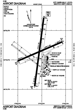
| Name: | Pitt-Greenville Airport |
| ICAO / IATA: | KPGV / PGV |
| FAA: | PGV |
Details |
| Type: | Airport (Part 139 Class I) |
| Use: | Public/Civil |
| Latitude: | 35°38'08"N (35.635694) |
| Longitude: | 77°23'03"W (-77.384082) |
| Datum: | WGS 1984 |
| Elevation: | 26 ft (8 m) |
| Runways: | 2 |
| Longest: | 7175 × 150 ft (2187 × 45.5 m) |
Time |
| Timezone: | UTC+29:08 (DST+32:08) |
| Local Time: | |
Weather |
| METAR: | KPGV | 041415Z AUTO 35006KT 10SM CLR 11/06 A3004 RMK AO2
|
| TAF: | KPGV | 041123Z 0412/0512 36010G16KT P6SM -RA BKN100
FM041400 01008KT P6SM BKN150
FM050100 VRB03KT P6SM SCT200 AMD LTD TO CLD VIS AND WIND
|
Related Locations |
| Nearby: | |
| Farthest: | YAUG: 11727 mi / 18873 km
Augusta [Augusta Airport], WA, AU |
Find: |
|
Other Information |
Maps:
|
Links:
|
Sources:
|
|