| Location |
| City: | | Honolulu, Oahu, Hawaii, United States |
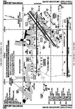
| Name: | Daniel K Inouye International Airport |
| ICAO / IATA: | PHNL / HNL |
| FAA: | HNL |
Details |
| Type: | Airport (Part 139 Class I) |
| Use: | Public/Civil |
| Latitude: | 21°19'04"N (21.317817) |
| Longitude: | 157°55'13"W (-157.920227) |
| Datum: | WGS 1984 |
| Elevation: | 12 ft (4 m) |
| Runways: | 4 |
| Longest: | 12312 × 150 ft (3753 × 45.5 m) |
Time |
| Timezone: | UTC+24:08 (DST+26:08) |
| Local Time: | |
Weather |
| METAR: | PHNL | 041353Z 01004KT 10SM FEW023 FEW035 21/17 A2992 RMK AO2 SLP132 T02110167
|
| TAF: | PHNL | 041120Z 0412/0518 33006KT P6SM FEW025 FEW045
FM042000 04013G20KT P6SM FEW025 SCT045
FM050500 04008KT P6SM FEW025 SCT045
FM051000 35005KT P6SM FEW025 SCT045
|
Related Locations |
| Nearby: | |
| Farthest: | GNZ: 12403 mi / 19961 km
Ghanzi [Ghanzi Airport], GH, BW |
Find: |
|
Other Information |
Maps:
|
Delays:
|
Links:
|
Sources:
|
|