| Location |
| City: | | St. Petersburg-Clearwater, Florida, United States |
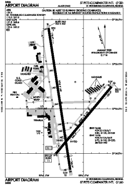
| Name: | St. Pete-Clearwater International Airport |
| ICAO / IATA: | KPIE / PIE |
| FAA: | PIE |
Details |
| Type: | Airport (Part 139 Class I) |
| Use: | Public/Civil |
| Latitude: | 27°54'31"N (27.908634) |
| Longitude: | 82°41'11"W (-82.686509) |
| Datum: | WGS 1984 |
| Elevation: | 10 ft (3 m) |
| Runways: | 2 |
| Longest: | 9730 × 150 ft (2966 × 45.5 m) |
Time |
| Timezone: | UTC+29:08 (DST+32:08) |
| Local Time: | |
Weather |
| METAR: | KPIE | 041353Z 06005KT 9SM OVC004 16/16 A3007 RMK AO2 SLP183 T01610161
|
| TAF: | KPIE | 041122Z 0412/0512 VRB05KT 2SM BR SCT003 OVC012 TEMPO 0412/0414 1/4SM FG OVC002
FM041500 06005KT 6SM BR SCT007 BKN020
FM041900 32006KT P6SM BKN200
FM050200 VRB03KT P6SM FEW050 SCT200
|
Related Locations |
| Nearby: | |
| Farthest: | USL: 11448 mi / 18424 km
Useless Loop, WA, AU |
Find: |
|
Other Information |
Maps:
|
Delays:
|
Links:
|
Sources:
|
|