| Location |
| City: | | Glasgow, Ayr, Scotland, United Kingdom |
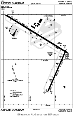
| Name: | Prestwick |
| ICAO / IATA: | EGPK / PIK |
Details |
| Type: | Airport (Aerodrome, Airfield) |
| Use: | Public/Civil |
| Latitude: | 55°30'34"N (55.509444) |
| Longitude: | 4°35'12"W (-4.586666) |
| Datum: | WGS 1984 |
| Elevation: | 65 ft (20 m) |
| Runways: | 2 |
| Longest: | 9800 × 150 ft (2987 × 45.5 m) |
Time |
| Timezone: | UTC+0 (DST+3) |
| Local Time: | |
Weather |
| METAR: | EGPK | 041350Z 27013KT 9999 FEW026 08/03 Q1013
|
| TAF: | EGPK | 041102Z 0412/0512 28015KT 9999 FEW012 SCT025 PROB40 TEMPO 0412/0415 6000 -SHRA BKN012 BECMG 0415/0418 24005KT BECMG 0509/0512 13010KT
|
Related Locations |
| Nearby: | |
| Farthest: | SZS: 11758 mi / 18923 km
Ryan's Creek, Stewart Island, STL, NZ |
Find: |
|
Other Information |
Maps:
|
Links:
|
Sources:
|
|