| Location |
| City: | | Paso Robles, California, United States |
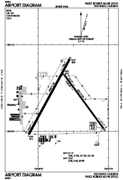
| Name: | Paso Robles Municipal Airport |
| ICAO / IATA: | KPRB / PRB |
| FAA: | PRB |
Details |
| Type: | Airport (Airfield) |
| Use: | Public/Civil |
| Latitude: | 35°40'22"N (35.672889) |
| Longitude: | 120°37'37"W (-120.627082) |
| Datum: | WGS 1984 |
| Elevation: | 838 ft (255 m) |
| Runways: | 2 |
| Longest: | 6008 × 150 ft (1831 × 45.5 m) |
Time |
| Timezone: | UTC+26:08 (DST+29:08) |
| Local Time: | |
Weather |
| METAR: | KPRB | 041353Z AUTO 19008KT 10SM -RA FEW025 BKN049 OVC085 09/08 A2966 RMK AO2 SLP043 P0001 T00940083
|
| TAF: | KPRB | 041419Z 0414/0512 19010KT 6SM -SHRA SCT015 BKN035
FM041700 21015KT 6SM -SHRA BR OVC025
FM042100 23020G30KT P6SM -SHRA BKN025 OVC040
FM050100 25015KT P6SM -SHRA OVC040
FM050300 25007KT P6SM -SHRA SCT025 OVC040
|
Related Locations |
| Nearby: | |
| Farthest: | ZSE: 11414 mi / 18369 km
St-Pierre (St-Pierre de la Réunion) [Pierrefonds], RE |
Find: |
|
Other Information |
Maps:
|
Links:
|
Sources:
|
|