| Location |
| City: | | Pontiac, Michigan, United States |
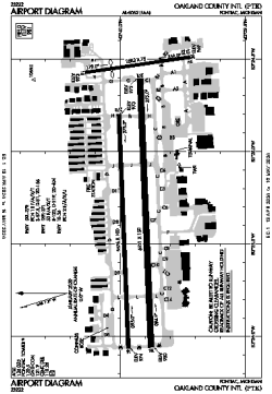
| Name: | Oakland County International Airport |
| ICAO / IATA: | KPTK / PTK |
| FAA: | PTK |
Details |
| Type: | Airport (Part 139 Class IV) |
| Use: | Public/Civil |
| Latitude: | 42°39'56"N (42.665636) |
| Longitude: | 83°25'14"W (-83.420505) |
| Datum: | WGS 1984 |
| Elevation: | 980 ft (299 m) |
| Runways: | 3 |
| Longest: | 6521 × 150 ft (1988 × 45.5 m) |
Time |
| Timezone: | UTC+29:08 (DST+32:08) |
| Local Time: | |
Weather |
| METAR: | KPTK | 041353Z 18005KT 8SM BKN048 OVC060 08/06 A2984 RMK AO2 SLP107 T00780056
|
| TAF: | KPTK | 041120Z 0412/0512 18009KT P6SM SCT040 BKN070 TEMPO 0412/0414 5SM BR BKN040
FM041900 18014G22KT 6SM -SHRA BR BKN015 OVC040
FM050000 21012G18KT P6SM OVC015
FM050400 25010KT P6SM OVC025
FM050900 29008KT P6SM SCT025 BKN100
|
Related Locations |
| Nearby: | |
| Farthest: | YAUG: 11283 mi / 18159 km
Augusta [Augusta Airport], WA, AU |
Find: |
|
Other Information |
Maps:
|
Links:
|
Sources:
|
|