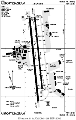
| Location |
| City: | | Busan, Korea (Republic of) (South Korea) |
| Near (Alt.): | Pusan |
| Name: | Gimhae International (Kimhae) |
| ICAO / IATA: | RKPK / PUS |
Details |
| Type: | Airport (Aerodrome, Airfield) |
| Use: | Public/Civil, Military |
| Latitude: | 35°10'46"N (35.179528) |
| Longitude: | 128°56'18"E (128.938222) |
| Datum: | WGS 1984 |
| Elevation: | 6 ft (2 m) |
| Runways: | 2 |
| Longest: | 10499 × 197 ft (3200 × 60 m) |
Time |
| Timezone: | UTC+9 (DST+11) |
| Local Time: | |
Weather |
| METAR: | RKPK | 041400Z 29005KT CAVOK 03/M08 Q1025
|
| TAF: | RKPK | 041100Z 0412/0518 33006KT CAVOK TNM02/0421Z TX11/0506Z BECMG 0504/0505 18006KT BECMG 0509/0510 33006KT
|
Related Locations |
| Nearby: | |
| Farthest: | SUEO: 12301 mi / 19797 km
Montevideo [Montevideo UIR], UY |
Find: |
|
Other Information |
Maps:
|
Sources:
|
|