| Location |
| City: | | Reading, Pennsylvania, United States |
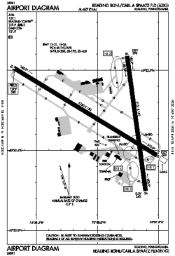
| Name: | Reading Regional/Carl A Spaatz Field |
| ICAO / IATA: | KRDG / RDG |
| FAA: | RDG |
Details |
| Type: | Airport (Part 139 Class IV) |
| Use: | Public/Civil |
| Latitude: | 40°22'43"N (40.378499) |
| Longitude: | 75°57'55"W (-75.965246) |
| Datum: | WGS 1984 |
| Elevation: | 343 ft (105 m) |
| Runways: | 2 |
| Longest: | 6350 × 150 ft (1935 × 45.5 m) |
Time |
| Timezone: | UTC+29:08 (DST+32:08) |
| Local Time: | |
Weather |
| METAR: | KRDG | 041354Z 00000KT 1 1/2SM BR CLR M01/M01 A3011 RMK AO2 SFC VIS 4 SLP204 T10061011
|
| TAF: | KRDG | 041305Z 0413/0512 VRB03KT 2SM BR FEW250
FM041400 VRB03KT P6SM FEW250 TEMPO 0414/0415 4SM BR
FM050800 VRB03KT 6SM BR OVC050
|
Related Locations |
| Nearby: | |
| Farthest: | YAUG: 11699 mi / 18827 km
Augusta [Augusta Airport], WA, AU |
Find: |
|
Other Information |
Maps:
|
Delays:
|
Links:
|
Sources:
|
|