| Location |
| City: | | Reno, Nevada, United States |
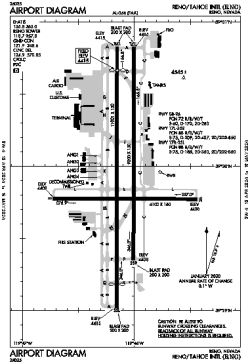
| Name: | Reno/Tahoe International Airport |
| ICAO / IATA: | KRNO / RNO |
| FAA: | RNO |
Details |
| Type: | Airport (Part 139 Class I) |
| Use: | Public/Civil |
| Latitude: | 39°29'57"N (39.499111) |
| Longitude: | 119°46'05"W (-119.768110) |
| Datum: | WGS 1984 |
| Elevation: | 4414 ft (1345 m) |
| Runways: | 3 |
| Longest: | 11001 × 150 ft (3353 × 45.5 m) |
Time |
| Timezone: | UTC+26:08 (DST+29:08) |
| Local Time: | |
Weather |
| METAR: | KRNO | 041355Z 17016G22KT 2SM -SN BR FEW009 OVC013 01/M01 A2939 RMK AO2 SLP949 P0002 T00111006 $
|
| TAF: | KRNO | 041138Z 0412/0512 18012G20KT P6SM VCSH SCT030 OVC040
FM041400 19012KT 1/2SM SN OVC009
FM041700 19012KT 3SM -SN BKN015 OVC030
FM041900 20019KT 4SM -SHSN BKN020 OVC030
FM050300 19014KT 2SM -SN OVC025
|
Related Locations |
| Nearby: | |
| Farthest: | FAME: 11205 mi / 18033 km
Marion Island, Prince Edward Islands, WC, ZA |
Find: |
|
Other Information |
Maps:
|
Delays:
|
Links:
|
Sources:
|
|