| Location |
| City: | | Rochester, Minnesota, United States |
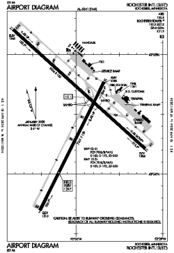
| Name: | Rochester International Airport |
| ICAO / IATA: | KRST / RST |
| FAA: | RST |
Details |
| Type: | Airport (Part 139 Class I) |
| Use: | Public/Civil |
| Latitude: | 43°54'30"N (43.908278) |
| Longitude: | 92°30'00"W (-92.500027) |
| Datum: | WGS 1984 |
| Elevation: | 1317 ft (401 m) |
| Runways: | 2 |
| Longest: | 9034 × 150 ft (2754 × 45.5 m) |
Time |
| Timezone: | UTC+28:08 (DST+31:08) |
| Local Time: | |
Weather |
| METAR: | KRST | 041408Z 29021KT 1 1/2SM R31/5000VP6000FT -FZRA BR OVC002 M06/M06 A2969 RMK AO2 PK WND 29028/1359 FZRAB07 P0000 I1001 T10611061
|
| TAF: | KRST | 041413Z 0414/0512 30017G24KT 1SM -FZDZ BR OVC002
FM041600 29017G26KT P6SM OVC008
FM050500 32010KT P6SM OVC012
|
Related Locations |
| Nearby: | |
| Farthest: | YAUG: 10824 mi / 17419 km
Augusta [Augusta Airport], WA, AU |
Find: |
|
Other Information |
Maps:
|
Delays:
|
Links:
|
Sources:
|
|