| Location |
| City: | | Buenos Aires, Ciudad Autónoma de Buenos Aires, Argentina |
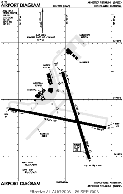
| Name: | Aeropuerto Internacional Ezeiza/Ministro Pistarini |
| ICAO / IATA: | SAEZ / EZE |
Details |
| Type: | Airport (Aerodrome, Airfield) |
| Use: | Public/Civil, Military |
| Latitude: | 34°49'20"S (-34.822221) |
| Longitude: | 58°32'09"W (-58.535832) |
| Datum: | WGS 1984 |
| Elevation: | 67 ft (20 m) |
| Runways: | 2 |
| Longest: | 10827 × 197 ft (3300 × 60 m) |
Time |
| Timezone: | UTC+31:08 (DST+33:08) |
| Local Time: | |
Weather |
| METAR: | SAEZ | 041400Z VRB03KT 9999 SCT040 24/14 Q1024 NOSIG
|
| TAF: | SAEZ | 041100Z 0412/0512 VRB03KT CAVOK TX28/0419Z TN19/0409Z BECMG 0412/0414 05008KT
|
Related Locations |
| Nearby: | |
| Farthest: | TAO: 12316 mi / 19821 km
Qingdao [Liuting Intl], SD, CN |
Find: |
|
Other Information |
Maps:
|
Links:
|
Sources:
|
|