| Location |
| City: | | South Bend, Indiana, United States |
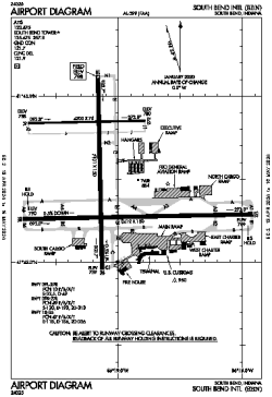
| Name: | South Bend International Airport |
| ICAO / IATA: | KSBN / SBN |
| FAA: | SBN |
Details |
| Type: | Airport (Part 139 Class I) |
| Use: | Public/Civil |
| Latitude: | 41°42'30"N (41.708224) |
| Longitude: | 86°19'02"W (-86.317336) |
| Datum: | WGS 1984 |
| Elevation: | 798 ft (243 m) |
| Runways: | 3 |
| Longest: | 8412 × 150 ft (2564 × 45.5 m) |
Time |
| Timezone: | UTC+29:08 (DST+32:08) |
| Local Time: | |
Weather |
| METAR: | KSBN | 041354Z 19010KT 10SM BKN018 BKN055 OVC090 09/07 A2977 RMK AO2 SLP083 T00890067 $
|
| TAF: | KSBN | 041129Z 0412/0512 19008KT P6SM VCSH SCT050 OVC080 WS020/22045KT
FM041600 18012KT 4SM -SHRA BR OVC015 WS016/23050KT
FM041800 20013KT 3SM -SHRA BR OVC006 WS016/23045KT TEMPO 0418/0422 2SM SHRA BR
FM050100 29010KT P6SM OVC012
|
Related Locations |
| Nearby: | |
| Farthest: | YAUG: 11168 mi / 17973 km
Augusta [Augusta Airport], WA, AU |
Find: |
|
Other Information |
Maps:
|
Delays:
|
Links:
|
Sources:
|
|