| Location |
| City: | | La Serena, Coquimbo, Chile |
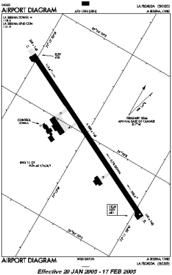
| Name: | La Florida Airport |
| ICAO / IATA: | SCSE / LSC |
Details |
| Type: | Airport (Aerodrome, Airfield) |
| Use: | Public/Civil |
| Latitude: | 29°54'59"S (-29.916388) |
| Longitude: | 71°11'58"W (-71.199443) |
| Elevation: | 481 ft (147 m) |
| Runways: | 1 |
| Longest: | 6358 × 148 ft (1938 × 45 m) |
Time |
| Timezone: | UTC+30:08 (DST+33:08) |
| Local Time: | |
Weather |
| METAR: | SCSE | 041400Z 26004KT 9999 SCT010 OVC013 17/15 Q1014
|
| TAF: | SCSE | 041030Z 0412/0512 30004KT 9999 SCT007 OVC012 TX21/0419Z TN15/0511Z TEMPO 0412/0414 4000 BR SCT004 OVC008 BECMG 0415/0417 28008KT SCT010 BKN015 BECMG 0418/0420 29012KT FEW010 SCT020 BECMG 0501/0503 29004KT SCT008 BKN012 BECMG 0504/0506 OVC010
|
Related Locations |
| Nearby: | |
| Farthest: | JIQ: 12402 mi / 19959 km
Qianjiang (Zhoubai) [Qianjiang Wulingshan Airport], CQ, CN |
Find: |
|
Other Information |
Maps:
|
Sources:
|
|