| Location |
| City: | | Puerto Montt, Los Lagos, Chile |
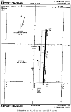
| Name: | El Tepual International Airport |
| ICAO / IATA: | SCTE / PMC |
Details |
| Type: | Airport (Aerodrome, Airfield) |
| Use: | Public/Civil |
| Latitude: | 41°26'20"S (-41.438888) |
| Longitude: | 73°05'38"W (-73.093888) |
| Elevation: | 294 ft (90 m) |
| Runways: | 1 |
| Longest: | 8694 × 148 ft (2650 × 45 m) |
Time |
| Timezone: | UTC+30:08 (DST+33:08) |
| Local Time: | |
Weather |
| METAR: | SCTE | 041400Z 31003KT 270V360 CAVOK 28/12 Q1009 NOSIG
|
| TAF: | SCTE | 041012Z 0412/0512 VRB03KT CAVOK TX30/0420Z TN10/0510Z BECMG 0414/0416 19010KT BECMG 0501/0503 VBR04KT BECMG 0507/0509 9999 OVC008 TEMPO 0508/0512 2000 BR SCT003 OVC006
|
Related Locations |
| Nearby: | |
| Farthest: | RLK: 12380 mi / 19923 km
Bayannur [Bayannur Tianjitai Airport], NM, CN |
Find: |
|
Other Information |
Maps:
|
Sources:
|
|