| Location |
| City: | | Houston, Texas, United States |
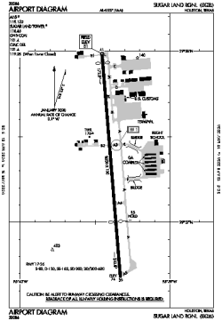
| Name: | Sugar Land Regional |
| ICAO / IATA: | KSGR / SGR |
| FAA: | SGR |
Details |
| Type: | Airport (Airfield) |
| Use: | Public/Civil |
| Latitude: | 29°37'20"N (29.622249) |
| Longitude: | 95°39'24"W (-95.656533) |
| Datum: | WGS 1984 |
| Elevation: | 81 ft (25 m) |
| Runways: | 1 |
| Longest: | 8000 × 100 ft (2438 × 30.5 m) |
Time |
| Timezone: | UTC+28:08 (DST+31:08) |
| Local Time: | |
Weather |
| METAR: | KSGR | 041403Z 15004KT 1/4SM FG VV002 21/20 A2993 RMK AO2 T02060200
|
| TAF: | KSGR | 041150Z 0412/0512 20004KT 1/2SM FG OVC003 TEMPO 0412/0413 1/4SM FG
FM041400 18004KT 1SM BR OVC004
FM041600 21006KT 4SM BR OVC006
FM041800 22008KT 6SM MIFG SCT009 OVC015
FM042000 24009KT P6SM SCT015 BKN025 OVC180
FM042200 21005KT P6SM SCT035 BKN150
FM050200 16005KT P6SM SCT008 OVC025
FM050900 18003KT 3SM BR OVC008
FM051100 17003KT 1/2SM FG OVC003
|
Related Locations |
| Nearby: | |
| Farthest: | CCK: 10992 mi / 17690 km
West Island (Pulau Panjang) [Cocos (Keeling) Islands], CC |
Find: |
|
Other Information |
Maps:
|
Links:
|
Sources:
|
|